r/dataisbeautiful • u/TA-MajestyPalm • 4d ago
OC [OC] Post-Pandemic Population Growth Trends, by US Metro Area (2022->2024)
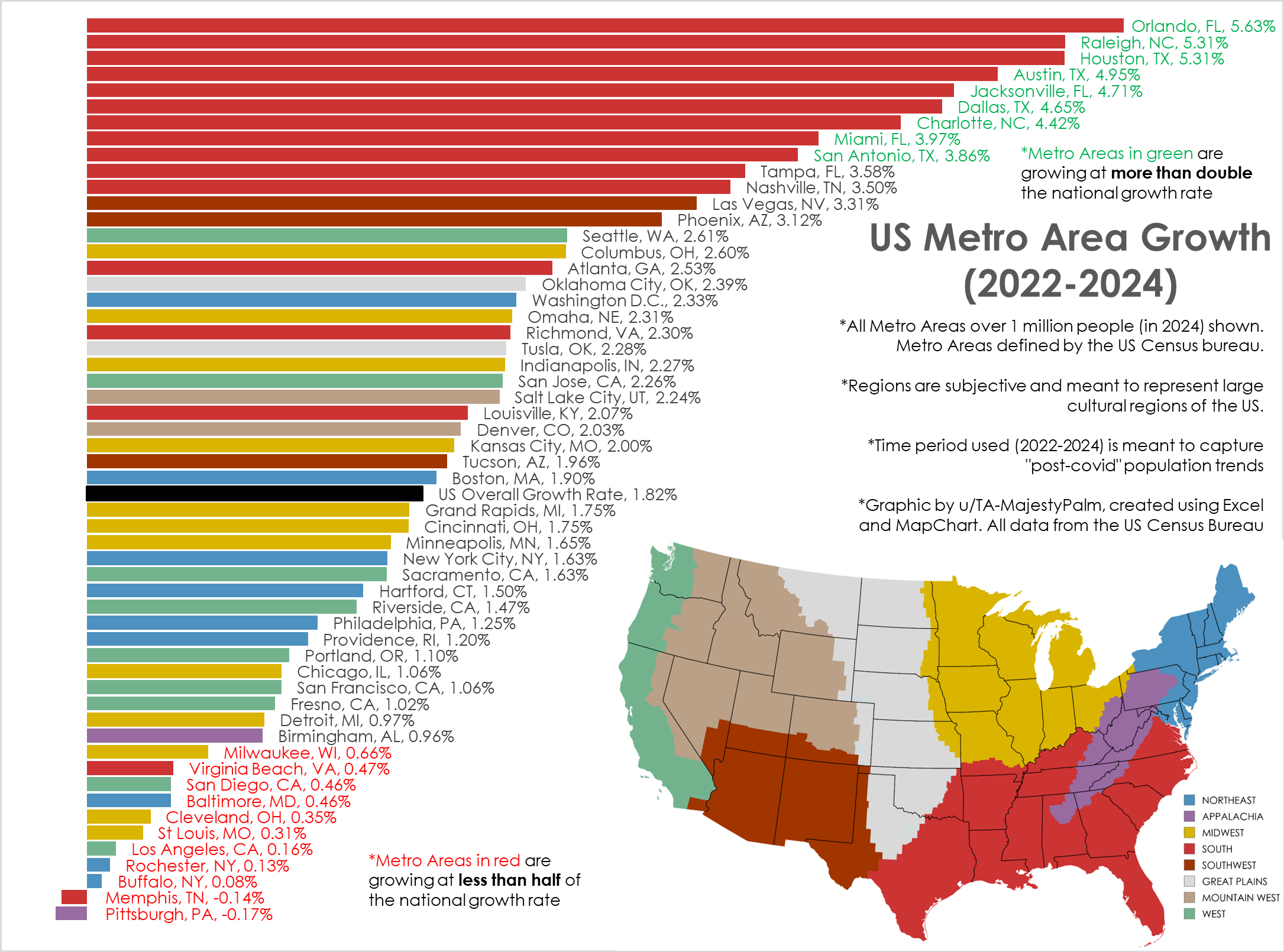
Graphic by me, created in Excel. All data from US Census here: https://www.census.gov/data/tables/time-series/demo/popest/2020s-total-metro-and-micro-statistical-areas.html
I've created similar graphics in the past, but usually from 2020-2024. This is not the best time frame as it combines the abnormal covid years with post pandemic movement.
This time frame (2022-2024) shows the most current and ongoing population trends of the last 2 years.
I also wanted to better categorize the cities into broad cultural regions vs the arbitrary geographic census regions.
881
Upvotes
5
u/Vospader998 3d ago edited 3d ago
I know the regions are arbitrary, but I'm going to make my augment because this graphic really aligns with that idea.
There should be a "Great Lakes" region. The cities along the Great Lakes are all culturally, ecologically, geographically, architecturally, and historically similar. This would include (from the list above):
Chicago
Detroit
Cleveland
Milwaukee
Buffalo
Rochester
Pittsburgh * (a railway in the mid-1800s and early 1900s connected Pittsburgh, Buffalo, and Rochester, effectively connected Pittsburgh to the region economically and culturally. Though, this could be argued either way, but it is usually included among the "Rust Belt" cities)
These cities all had major populations for essentially the same reason - surrounding a good diversity of resources that could be transported to a shipyard that was connected to the global trade network. The St. Lawrence, and eventually the Erie Canal, connected the Great Lakes to the Atlantic Ocean, and thus connected to global trade. Resources such as timber, coal, iron ore, salt, food crops, animal products, and an abundance of fresh water, all of which were all incredibly important for maintaining large industrial populations.
This abundance of resources, and the connection to global shipping trade, meant these are all prime locations for new factories to import raw materials, export manufactured goods, and sustain large working populations. What became known as "The Steel Belt" was the industrial powerhouse of the United States from the early-1800s to the mid-1900s.
Once industrial factories and jobs started moving overseas, trucking transportation started taking over shipping and rail, and economies started shifting to other areas, the region once known as "The Steel Belt" slowly became known as "The Rust Belt" as factories were closing down and people moved away en mass. Today, all across the Great Lakes you'll see an abundance of abandon buildings in all those cities. The populations stopped depopulating as rapidly, stagnated, and some have even see some growth (though usually minor).
I would argue this shared history, on top of a really similar ecology and climate (dominated by the lakes, making it wet and more temperate), would make it a distinct region that shares more similarities with each other than other, potentially geographically closer cities.
For example, Buffalo is way more similar culturally to Chicago or Detroit than it is to New York City, Boston, or Baltimore. And Chicago is way more similar to Buffalo than it is to St. Louis or Minneapolis.
And looking at the graphic here, it would explain a lot of these cities that have low population growth, but with still relatively high populations.