Pro Coverage, Highlights and News
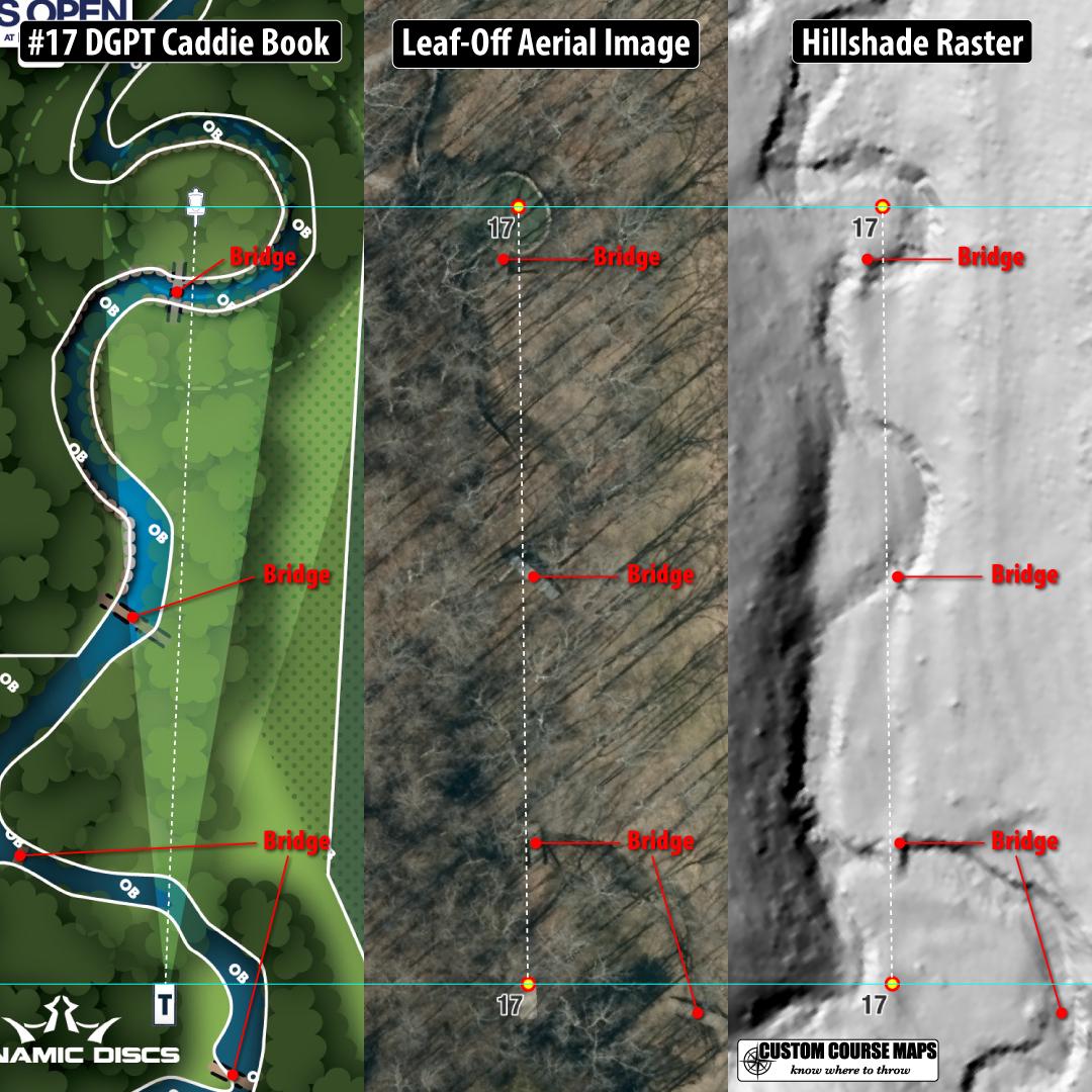
Hole 17 Idlewild - This is why elevation data matters (follow up to the earlier hillshade post.) Straight line to pin crosses the creek four times as seen in the raster image (right). Bridges are clearly visible in the aerial image (middle)
The green is 6 feet below the tee. But its not about elevation. Its the elevation data that helps map it accurately. You did notice the difference in how the stream runs through?
I mean, I've been there. I know exactly what it looks like. I do not find the sign confusing or lacking in information. I do not see the advantage of knowing that the hole is supposedly 6' below the pad. The hole is flat. The basket is directly in front of you and so is the creek.
Then why did the pro tour draw the creek in the wrong place halfway down the fairway, Why are the bridges in the wrong place. Why is the green the wrong size?
No one standing on that tee pad, looking down the fairway, is confused by the tee sign. It shows all of the import landmarks in relatively correct positions. The OB is marked in a way that the players can tell what is intended. That is the point of the tee signs and caddy books. They improve these a little every year. There are holes that could benefit from elevation profiles, and lo and behold the pro tour added them. You, of course, have negative things to say about out that.
Here’s the thing, I like your signs. They have good and useful information. They look good. But you post this stuff constantly here and in the course designers group on Facebook. You come off as pretentious and arrogant. You are clearly marketing your business, but are trying to deny it. That is why you are getting negative comments and downvotes. Do with that what you will.
Did you have any luck with the elevation link I sent you in the other thread? You seemed interested in getting help and I told you exactly what you wanted to know.
Also, Reddit allows everyone to be anonymous. I chose to sign up as exactly who I am and now that's self promotion? Seems like a double standard.
Funny you should mention the designers group on Facebook. Please point out anything there that is pretentious and arrogant. I only post there when some asks a question and many time other people tag me in that group because they know my expertise. I think your reading something into those posts that simply isn't there and maybe now posting here with a bit of an agenda.
The elevation profiles in the caddie book are not correct but they should be a the pro level.
I could post all kinds of criticism with anonymous accounts and burner emails but I am here as me.
Rather than simply tear down the efforts of the tour, I am posting a solution to a problem and everyone interprets that as selling a product.
While my username is not my name, I am easily identified by my post history. I haven't had time to search for the maps I am looking for yet, but I appreciate the resource. I am a course designer and I make signs for courses and caddy books. The elevation contour lines help add context to a 2D image. The maps I've been using only have 10' contour lines, which I have found to be insufficient.
If I were to post a photo of one of your signs and rave about how awesome they are, no one would think that was weird. On the other hand, if I post a picture of my own signs and then proceed to explain to everyone how they are superior to everyone else's signs, people view that differently. If people value the content, they will be willing to add it to their signs or purchase yours.
If you really wanted to fix the signs on tour, you would be contacting the DGPT. If I had to guess, I would say that you have, and that they don't want to pay what you are asking.
Just use words? Verticality on a top down view isn't readily obvious, but whatever radar/lidar/whatever thing shown here doesn't add anything meaningful to a viewer, does it? It doesn't really help us visualize the elevation, it doesn't anchor the number any better than topographic contour maps, imo.
Like, I'll say it's neat and an interesting look at the earth below the plants, but maybe I need a hint as to why "better elevation data matters". Sell me on your vision here, how can this data enhance the viewing experience for me?
I'm confused, are you trying to say you think they should have all of this on the tee sign? Or just pointing out that the drawing of the river is very slightly off?
...and the shape of the creek or the size of the green? I am trying to show that it can be mapped more accurately and elevation data is a way to do that.
I think you're blowing up a problem and thinking of a solution for this blown up problem. Reading this post, the main issue is that on the left picture the creek is a couple (centi)meters or inches or whatever to the left compared to how it actually seems to be. So the solution would be to just edit this image. I'm not sure why the elevation has anything to do with this.
But you do seem like a butt hurt asshole though. No idea why you are coming so hard at the community you are clearly trying to sell your idea to who are giving you pretty strong feedback that this just doesn’t matter to them.
People have eyes. The hole map isn't supposed to be something you look at without also looking out into the fairway. It's not like you look at the map and then close your eyes to throw. People can see the slope. It's right in front of them. Go sell your tee signs somewhere else.
So how do viewers online get to stand on the tee and look around? The hole maps provided by the same people that sell coverage are incomplete and inaccurate.
Tee signs are for people playing the course. That's literally why they are called TEE signs, because it is a sign for the teeing area. If you want to make some super mega complex sign that is information overload so you can understand every centimeter of undulation from the comfort of your couch for a course you've never been to, then great, go for it, but that doesn't mean there is something wrong with the TEE sign.
You sound kinda angry and stuck on semantics, yes? Agreed, these signs are on the tee of the pro tour but they are also compiled into a caddie book and posted on the pro tour website for viewers that have paid for a subscription to view during online coverage, which they probably from their couch. The information has flaws. I am pointing that out.
It's not so much that you're wrong. It's more that you're annoying. I'd actually rather read a post from DiscGolfFanatic than yet another one from you.
Please elaborate on how you think that is. I'm not selling anything, not asking you to click anything, no phone number to text or call. I am reporting on what the pro tour is doing and showing where they fall short. There is a logo there to show where the information comes from and to back up the validity of the content.
so you don't sell tee signs? or kiosk maps? of all the things the pro tour is falling short on .. elevation is not even on anyone's list. the pros have eyes and practice rounds to figure it out.
If I do sell signs, am I selling them here? Am I trying to get pros to buy something they don't need? No!
Is the pro tour selling access to online viewing of a course people are not there to see in person and then providing a product describing that course that is has errors? Yes.
Maybe re-read what I posted. Its not about elevation. It's about elevation data in map making that allows those maps to be more precise.
Look through the replies from my other posts and see how many think better detailed maps help understand what they are watching online. If I do create tee signs that others want to purchase for their course (none of which happens on Reddit) then I am building expertise in the subject matter that bolsters my opinion about what the pro tour is or is not doing which is why I am reporting on it.
How is it you know exactly what the pros don't need.
your user name is your business name.. get out of here with that shit.
..tee shirt companies are falling short with disc golf shirts I'm just pointing out that these shirts are better.
So a business name is against the rules? Lame comparison BTW disc golf shirts aren't misrepresenting what viewers see on coverage. I should start posting using spam accounts with burner emails. That will fix everything.
hmmm, don't see business name there but you still didn't answer how I am promoting that. Nothing is for sale anywhere, you don't have to sign up to see the samples or click on an external link. You also can't define what "improved elevation products" even means. There is no listing of a website, Youtube channel or other social media.
The first paragragh also says at the discretion of the moderators. I have messaged them multiple times to get an explain what they think it is and they have never answered.
this is what you are spamming and quit trying to make it about viewers at home or pro disc golfers have this need for this info or the dgpt failing , falling short , misleading etc. no one fucking cares
No idea why people would be against making the signage and viewing experience more accurate. It’s not the biggest deal ever, but it is definitely an improvement. It also helps put into perspective crazy shots imo.


17
u/larrod25 Team Westside Discs/ Team NADGT 11h ago
This hole is perfectly flat. What are we learning from elevation data here?