r/vancouverhiking Jun 23 '25

Trip Reports First day of SUMMER!

Thumbnail
gallery
709 Upvotes

Officially SUMMER! šŸŒž Just wanted to share some shots from our recent backpacking trip to Garibaldi Lake this past weekend.

We were welcomed with beautiful sunshine on Saturday, so we took the chance to chill and soak it all in by the lake. On Sunday, we made our way up to Panorama Ridge — while we couldn’t see the lake from the top due to the clouds, the hike was still so worth it!

We were lucky enough to spot some wildlife too — including the elusive owl, the chunky resident marmots, and a whole lot of wildflowers in full bloom. Nature really showed off this weekend! šŸŒ¼šŸ¦‰šŸ¾

r/vancouverhiking 13d ago

Trip Reports Cinnamon Bears at Brunswick Lake

538 Upvotes

Sitting lakeside on Saturday afternoon chilling with my fifty new best friends and I hear someone mentioning that they see a bear. Funnily enough it was the guy who just smoked a big fatty (I know it’s against park rules but at least he wasn’t flying a drone or anything stupid like that). I wonder if we might have missed their appearance if he hadn’t been staring at the hillside.

r/vancouverhiking Jul 01 '25

Trip Reports The Black Tusk (June 30.2025)

Thumbnail
gallery
634 Upvotes

Great conditions all the way up the Tusk. The chimney is dry and most of the scree field is still covered by snow

r/vancouverhiking 20d ago

Trip Reports More from my solo trip to Mt Pitt & SE Garibaldi Park

Thumbnail
gallery
439 Upvotes

You can find more photos on my Flickr and the trip report on Treeline to Alpine.

r/vancouverhiking Aug 03 '25

Trip Reports Golden Ears

Thumbnail
gallery
697 Upvotes

Beatiful Sunset at the Camp - This is a hard hike, make sure you are prepared. No water source between Alder Flats and the ridge. No access to toilet until Aug.8. Lots of bugs.

r/vancouverhiking May 31 '25

Trip Reports GROUSE GRIND

260 Upvotes

Super happy to have made it outside and gone on this trail. But wanted to post here to tell the girl who told me at 3/4 to "stick to the left, if you're taking a break" that I WAS LITERALLY MOVING, albeit slowly. Just trying to push past, one step at a time.

There are some areas that are super narrow on the trail so it's kind of hard to figure out which end to stick to to not "get in the way" -Grouse's website says stay on the right, so I did.

But can we all collectively agree to have some compassion when on the trail - trying to get your PB does not exclude you from acting like a decent human being. Most of us are sweaty, tired, and cranky near the end, honestly trying to just make it through that last bit, so can we not make it WORSE by mocking someone that is slower than you?

Were there groups of people blocking the steps at times? Yes. I just walked around. Was it annoying? Yes. Did I find the need to use a snide tone and comment? No. Why? Because why is it my business to say anything - who gave me the audacity? Being fast or more athletic does not give you a free pass to be a jerk.

Definitely soured the experience of getting to the top. But I'm putting the call out to all the slow hikers to go to Grouse, and complete the grind at your own pace - it apparently irks these wannabe athletes to see people working on themselves and progressing.

r/vancouverhiking Apr 27 '24

Trip Reports B.C. park's closures set a precedent for other parks

Thumbnail
vancouversun.com
180 Upvotes

r/vancouverhiking Jul 13 '25

Trip Reports Started hiking at 2:30 am to catch the sunrise from the summit of Brunswick (July 12th)

Thumbnail
gallery
648 Upvotes

Looking out towards the lions and Harvey

r/vancouverhiking Jul 21 '25

Trip Reports Golden Ears trail report from last weekend!

Post image
363 Upvotes

Did the golden ears summit trail Friday, back down Saturday. Tent pads at the ridge were full by 4pm on the Friday, trail to the summit was doable but pretty unclearly marked with a bit of snow and a little sketchy in deep fog. Looked like 30+ people heading up early Saturday morning, so would recommend going on a weekday if you want a tent pad! No water between Alder Flats and Panorama Ridge, lots of water at the upper campground. Bugs were constant but they didn’t bite, just irritating.

r/vancouverhiking Apr 14 '25

Trip Reports Climbing Behind Garibaldi Lake - Guard Mountain & Deception Peak - April 13th, 2025

Thumbnail
gallery
583 Upvotes

Guard Mountain and Deception Peak are located on the far (East) side of Garibaldi lake, roughly on the crest of the Sphinx Glacier. These peaks are "center of frame" from Panorama Ridge.

These are the last two peaks on the Sphinx Glacier horseshoe that my brother and I hadn't yet climbed, and we decided to grab them both in one go yesterday with the great weather and avalanche forecasts.

We left Vancouver around 2:00 AM, and were hiking up the Rubble Creek switchbacks by 3:30 AM. We had our mountaineering boots in our bag, and managed to make due with trail runners all the way to Lesser Garibaldi Lake, before making our first gear transition. From there we put on our snowshoes and began the 5km plod across the lake towards Sphinx Bay.

We gained the South Ridge of Guard Mountain via a narrow gully, and approached the first summit tower by connecting 3rd class steps and moderate snow pitches. As we neared the summit, a family of mountain goats peered down at us. By the time we summited the first tower, the goats had all casually a 5th class band of rock and descended a 70 degree snow slope towards Sentinel Bay.

We made a 4th class traverse over to the second summit tower, which I think is actually shorter. Afterwards we simply reversed course, and headed over towards the Guard-Deception col. Deception was essentially a walk-up, with a very short snow pitch to gain one of the summit spires. We climbed the two tallest, unsure of which was actually the true summit.

The Sphinx Glacier area is one of my favourite places in BC, and these two peaks did not disappoint. Stats came in at around 36km, 2100m gain, finishing in just under 11 hours.

r/vancouverhiking Aug 04 '25

Trip Reports Garibaldi Lake Circumnavigation

Thumbnail
gallery
333 Upvotes

Garibaldi Lake is considered one of the gems of the Sea to Sky, with hundreds of tourists flocking to see its turquoise-blue waters. No introduction is needed—you can scour the internet for numerous trip reports and guides on the Instagram-famous Panorama Ridge and Black Tusk trails. However, these only scratch the surface of the area, and few venture beyond. I’ve always yearned to explore this region further, off the beaten path.

On August 2, 2025, our party of three completed the Garibaldi Lake circumnavigation lower route in approximately 20 hours, covering 49 km and 3,200 m of elevation gain. We opted for the lower route, given that the more documented high route—traversing through Castle Towers and Mount Carr—is a more technical counterpart involving extensive glacier travel and scrambling. Besides, I’m saving Castle Towers and the Phyllis Engine for another trip.

When researching the route, I found mostly reports of the high route. I was able to piece together some details from various sources, but one complete trip report by Climber Kyle was instrumental to our success. Climber Kyle, if you’re reading this: you’re an absolute beast for completing this in 13 hours. I hope to be as efficient in the mountains as you one day.

Below, I’ve summarized a few notable sections of the circumnavigation:

Rubble Creek to Panorama RidgeThis was an uneventful plod through the switchbacks. We made it to the top in two and a half hours. It was sobering to see a party celebrating their ascent, realizing this was just the beginning of our day.

Panorama Ridge to Sphinx BayWe followed the obvious path beneath Gentian Peak until it dissipated. Interestingly, we noticed periodic flagging tape and cairns, which helped guide us. Still, routefinding was imperative.

We were able to avoid heavy bushwhacking as we approached the bump guarding Sphinx Bay, but the descent through unavoidable alders and deadfall was horrendous. The clouds of bloodthirsty black flies were the cherry on top. This slow, laborious section turned into a true sufferfest. I was hoping and praying we’d find a way across Sphinx Bay, as I was dreading the thought of backtracking. I can foresee this route becoming unmanageable in the future once the alders become too thick.

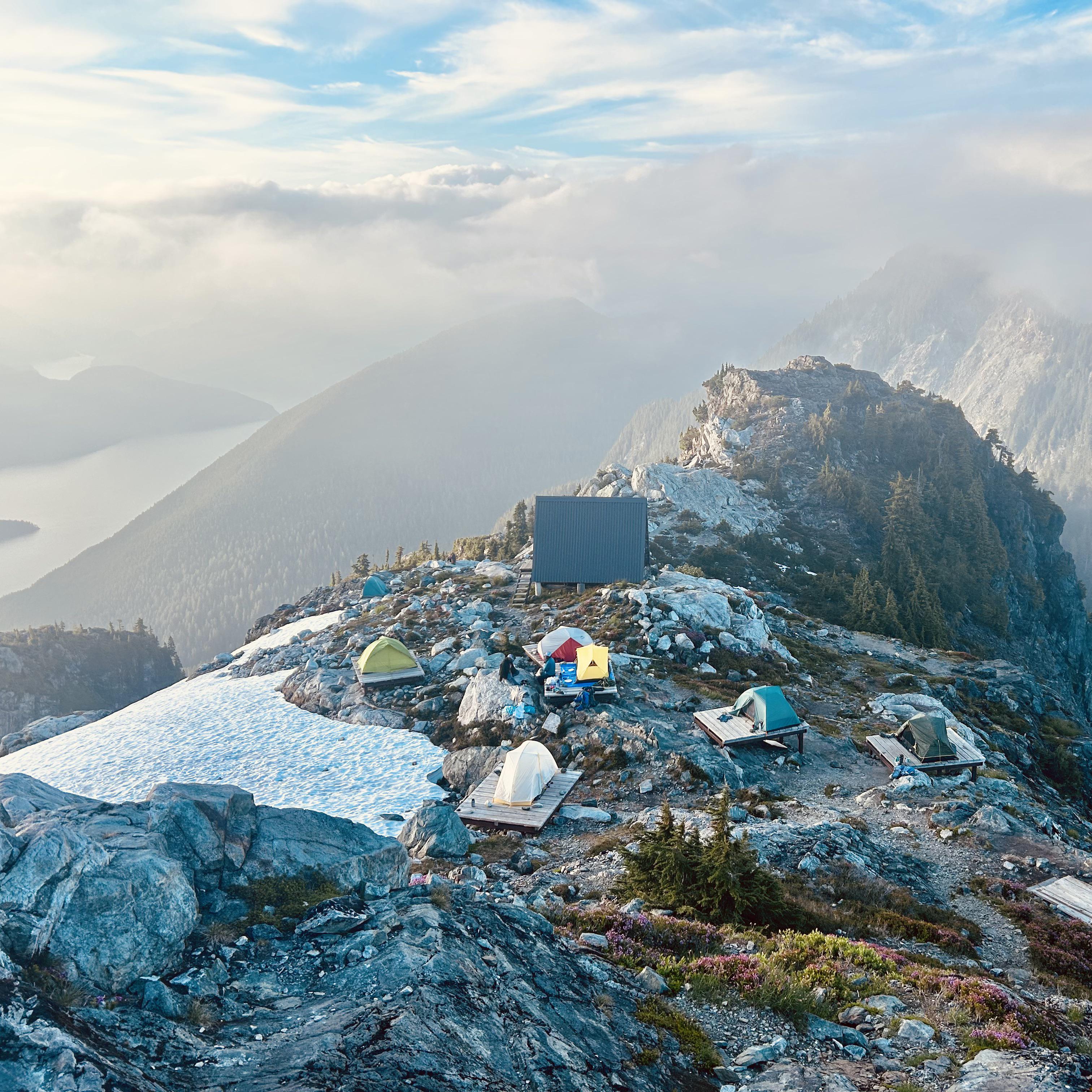
We visited the Burton Hut briefly before attempting the crux of the route. The hut was well equipped with food and cooking gear. It’s spacious and well-kept (shoutout to the VOC). I’d definitely love to revisit the area if I ever get into ski touring.

We initially attempted to ford the Sphinx Bay runoff channel from the mouth of the bay. After evaluating it, we realized it wasn’t feasible—the water appeared too deep. We walked the length of the channel, battling alders and trying to find a safe crossing. Most options were either too deep or the water was too rough for our comfort. We considered circumnavigating the body of water feeding the channel, but after reviewing satellite imagery, realized it wasn’t feasible due to the dense brush.

In retrospect, it might be possible to avoid the channel altogether by traversing and descending further into the bowl of Sphinx Bay. After an hour of troubleshooting, we found a crossing point upstream of where Climber Kyle forded. The water was thigh-deep and frigid. At this point, we were fully committed to completing the circumnavigation.

Sphinx Bay to Sentinel Bay

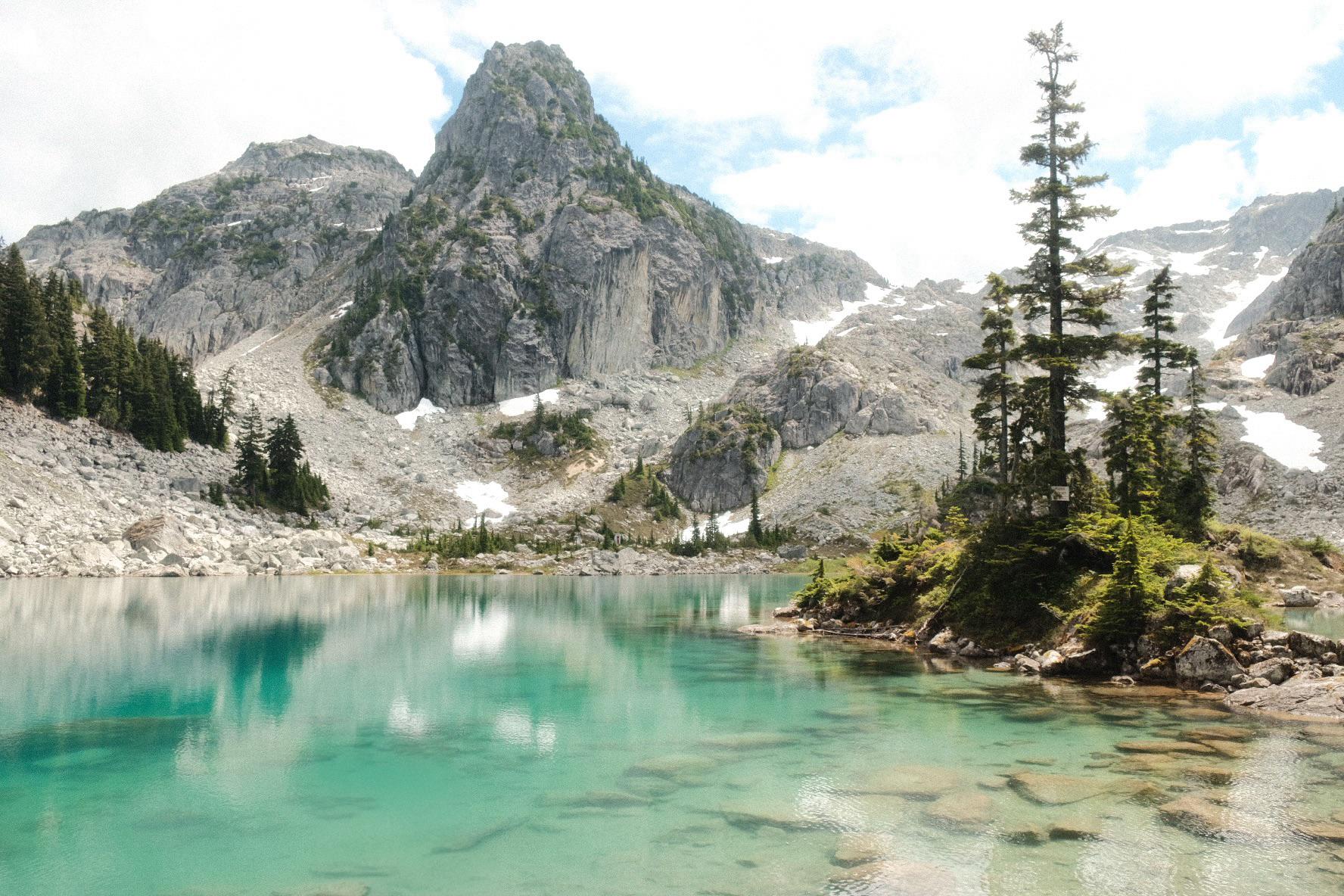
Climbing to Guard Glacier was fairly straightforward via boulder hopping and scree. We avoided most of the glacier by staying west, close to Guard Mountain. We donned microspikes for a short snow section. Though sections of blue ice protruded through the snow, they were easily avoidable.

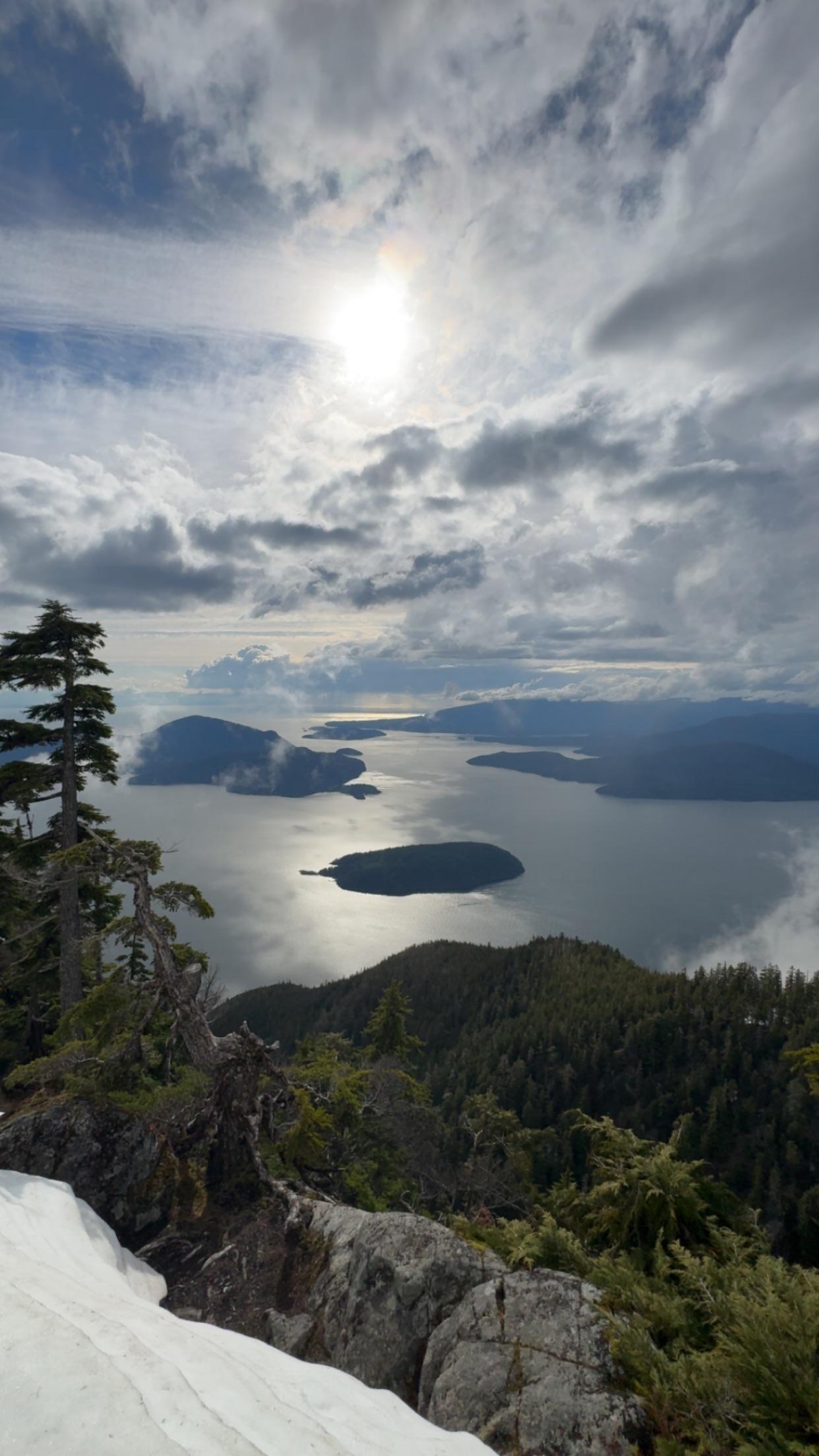
We had initially planned to climb Deception Peak or Guard Mountain, but time didn’t permit. As we approached the descent into Sentinel Bay, we were rewarded with breathtaking views of Mount Garibaldi and The Table—the next section of our journey. The descent was steep, and a fall would have been serious.

There were several water crossings at Sentinel Bay, though none as challenging as those at Sphinx Bay. Of note: this was the final source of running water until reaching Garibaldi Lake from Mount Price.

Sentinel Bay to Table Meadows

Eventually, we reached the ascent to The Table. From across Sphinx Bay, it deceptively looked like 4th-class terrain, but it proved mellow upon closer inspection. The rock was quite loose, so rockfall was a real concern—especially if you have someone following you.

We gained the plateau leading toward Table Mountain, then climbed an additional bump while trending west to avoid further bushwhacking. We descended the scree slope from The Table, which was a fun rock-ski down, and reached the start of Table Meadows.

Table Meadows to Mount Price

By this point, we were quickly losing daylight. I’m not sure if the route to Mount Price from Table Meadows is inherently convoluted or if we just struggled to find our way with headlamps, but we were periodically confused, trying to follow the GPS.

We stayed north of the meadows, crossed two creek beds, and eventually found our main line going up—though it wasn’t obvious. This involved bushwhacking until we reached a shale section approaching the Price–Clinker col. We were well behind schedule by now, and it was pitch dark, but we pressed on to summit Mount Price.

Mount Price to the Car

The descent down Mount Price was laborious, with occasional boulder crossings. The trail was hard to follow in places, partly due to fatigue, and partly due to overgrowth. Still, we were grateful to be on a somewhat established route.

This was my first time on the Mount Price trail in summer, and I don’t think I’d return—it's a long, unrewarding plod. Morale was boosted once we hit the Black Tusk ranger station. We hadn’t seen anyone past Panorama Ridge all day, so it was refreshing to finally encounter signs of human activity. After filtering water and having a quick nutrition break, we completed the final, unremarkable 9 km back to the car.

Summary

This is a true wilderness trip, with significant elevation gain and high commitment. It was definitely the trip of a lifetime. I would only recommend it to parties that move fast and efficiently, have strong routefinding skills, and a high tolerance for long, punishing days in the mountains.

I’ve long wished for more trail development in BC, as many of our peaks remain inaccessible or require arduous plods. Over the years, I’ve also noticed a striking uptick in the number of visitors to our parks, with congestion in the Sea to Sky corridor creating a host of separate issues. But after visiting the wilderness beyond Garibaldi Lake, I hope the beauty of places like this is preserved and kept wild.

r/vancouverhiking 8d ago

Trip Reports Hanes Valley loop Report

Thumbnail
gallery
231 Upvotes

To start! Stats and direction: Started at Grouse base and took Baden Powell to Lynn -> Norvan -> Hanes -> called it at chalet since I was pretty done. So I feel I have to go again to close the loop fully.

Distance: 25.04km Elevation: 1754m Time: 6h27m

Spent most of the hike alone on Baden Powell, lots of people on Lynn Valley walk to Norvan falls - shout out to the dudes I won’t describe who yelled ā€œhey bearā€ after I passed them and laughed at that..I hope you’ve always get little rock’s in your shoes that you can never get out.

Hanes was Really well Marked and flagged all the way through, the log bridge was easy to navigate, and the view when the trail opens up to the valley was incredible. I’m gonna to hike this again without any doubt.

The rock/boulder field was well marked but you get a lot of sun, the ascent was a punishing but fun. It makes you earn it. I had some fun with the echos you get near the top of the climb, still can’t get over how lovely the view was.

I went through 4.2L of water on a cool day, brought lots of energy bars and gels and used most.

Thanks for reading!

r/vancouverhiking Aug 05 '25

Trip Reports Death March from Deep Cove to Horseshoe Bay via Baden-Powell (Aug 3, 2025)

Post image
254 Upvotes

r/vancouverhiking 7d ago

Trip Reports Hanes valley loop

Thumbnail
gallery
216 Upvotes

Just finished one of the hardest hikes of my life. Thank god i had a stick. 14 miles. I dont know where i got my info but i remember seeing on alltrails that it takes 6 hrs to complete, which is false. so i started at 12 and ended up finishing at 9pm. Got so dark that i had to use my phone flashlight which was dim as shit until i realized it was on the dimmest setting. Went through 5 liters of water and ate 3 cliff bars.

Have to mention that i went clockwise, so i ascended grouse mt and descended into hanes valley, which was the most excruciating downclimb/scrambling with my completely cooked legs. Had to moan through it all, which was very freeing with no people around.

Anyone sees my stick tomorrow please take good care of it as well as it did me.

r/vancouverhiking Jul 31 '25

Trip Reports Panorama ridge on film

Thumbnail
gallery
510 Upvotes

r/vancouverhiking 24d ago

Trip Reports Joffrey lakes not over rated after all

Thumbnail
gallery
132 Upvotes

Finally got the reservations and some time to do Joffrey lakes and I can see why it's so busy. Relatively easy hike and an amazing payoff with views at all 3 lakes. Sadly lost my wedding band in lake two while swimming. Doubled back when I noticed it and couldn't find it anywhere. It's in the area in the second photo, so if any metal detecting enthusiasts go check it out :) happy to pay a reward if someone has more luck than me.

r/vancouverhiking Aug 29 '24

Trip Reports Stop asking about park passes!

270 Upvotes

The pass system exists to prevent erosion on certain high-foot traffic trails. It does NOT exist just to limit parking. If you’re trying to work the system and get onto the trails before park rangers show up- you don’t actually give af about nature- you’re doing it for your own entitled and selfish reasons. It blows my mind how many people claim to love nature but really just love using and abusing it. The pass system exists to protect the fragile ecosystems that ppl trample through when the trail is to busy to fit them all, to protect the ecosystems, and to conserve these beautiful areas. Think about that after you sneak in and then post a cute pic on Instagram pretending to actually love the mountains that you’re contributing to destroying.

r/vancouverhiking Jul 02 '25

Trip Reports Canada Day in the Whitecap Alpine - July 1st, 2025

Thumbnail
gallery
379 Upvotes

Whitecap Mountain is the 3rd tallest peak in the loosely defined area of South West BC. It is located South East of Gold Bridge, requiring at least 5.5 hours of driving to reach the trailhead off of Kingdom Lakes FSR, regardless of which route one takes.

We took the "high route" which ascends out of the Cadwallader Creek valley into the stunning McGillivray Pass. From there Whitecap itself finally becomes visible, and can be approached via a ~400m descent into the Connel Creek valley, before a massive 1100m climb from the valley bottom to the summit of Whitecap.

Conditions are absolutely perfect in the Whitecap alpine, with stunning wildflowers and verdant valley slopes. This is a big hike, and stats came in around 30km, 2500m gain, over almost exactly 11 hours.

r/vancouverhiking Apr 10 '25

Trip Reports Sea to sky summit April 5th

Thumbnail
gallery
479 Upvotes

The trail was dry with only lights mud around waterfalls. The rocks for dry and the only snow was 200 m to the top and pretty much cleared from the trails. I took us almost 6 hours because we accidentally miss the cutoff for see the sky and we're on our way to peak 3 on the chef, so we had the back truck. I love seeing the amount of people of dogs on the trail that was a cool bonus very fun hike. I wear a double knee brace for meniscus issues and have a back brace for a sciatic and was still able to do it just fine.

r/vancouverhiking May 08 '25

Trip Reports St Marks Summit

Post image
409 Upvotes

Me and 2 of my friends who are just beginner hikers have been trying local short hikes such and tunnel bluffs and other shorter hikes recently we decided to try unnecessary mountain. We reached the mountain at 1100 expecting an easy hike we wore runners and shorts no shirts no jackets. Easily one of the stupidest ideas after meeting a few people and being told it’s steep we expected it to just have a little snow. Boy were we wrong we ended up taking 3 and half hours climbing up the steep mountains with wooden sticks we found on the way up and basically tumbling back down the mountain on the way back. Tdlr prepare for this hike there is still way too much snow

r/vancouverhiking Apr 28 '25

Trip Reports Overnight Trip To A Remote Garibaldi Giant - Mount James Turner - April 25th & 26th

Thumbnail
gallery
480 Upvotes

Myself, my brother, and a friend set out to make an attempt on a remote peak in central Garibaldi Park named Mount James Turner. James Turner requires crossing 5 or 6 named glaciers just to reach the base, and then a steep snow climb to the summit. With stable weather and avalanche forecasts we knew this was a great opportunity to make an attempt.

After linking the Wedgemount, Weart, Needles, and Chaos glaciers we finally reached the headwaters of the Berna glacier, where we setup a basecamp. We were now a mere 4km from the summit, and would be able to make our summit push in the early morning, aiming to summit and descend all before the sun hit our route.

We had read some sparse beta online about the SE face, and various cruxes previous parties had encountered, but due to equal-ish parts good planning and good luck we chose a line that allowed us to go directly to the summit without any false starts or backtracking. There was a single steep mixed step, which we would opt to rap on the way down, but otherwise it was a straightforward, albeit steep, snow climb.

We summited about 15 minutes before sunrise. James Turner is a tall and isolated tower in the heart of Garibaldi, and when the sun breached the horizon we were rewarded with some of the best mountain views I've been lucky enough to experience.

Eventually we reversed course, and made it back to camp without issue. We rested, then packed up and headed out, opting to take a "shortcut" by climbing directly over the summit of Peggy Peak to regain the Weart Glacier.

This was an amazing trip, and a lifetime climbing highlight for me. Stats, in total, were around 35km and 3500m gain.

r/vancouverhiking Aug 04 '25

Trip Reports Mount Tricouni

Thumbnail
gallery
256 Upvotes

We did Tricouni yesterday via iceberg lake and the north ridge which is NOT hiking. But the area is stunning and I think the hike up to iceberg lake would be worth it or the scramble up Tricouni peak via the scramble route southwest ridge. The area is stunning and I’m totally recommend it if you can get into the area

r/vancouverhiking Jul 28 '25

Trip Reports Watersprite didn’t disappoint

Post image
462 Upvotes

r/vancouverhiking 24d ago

Trip Reports Garibaldi Lake - Panorama Ridge. šŸžļø

Thumbnail
gallery
250 Upvotes

Garibaldi Lake / Panorama Ridge - moderate hike with a couple of brief scrambles, crystal-clear water, and hands-down some of the best views on earth, including Garibaldi Lake and Black Tusk. Absolutely breathtaking.

r/vancouverhiking Aug 09 '25

Trip Reports Flatiron via Needle peak Trail

Thumbnail
gallery
223 Upvotes

A bit steep in the first few km with lots of roots but should be manageable if you take your time. Once out of the forest you will be rewarded with stunning view. We did not hike up the needle peak as we have done this a couple ot times. We ended up staying here due to road closure on the way to our planned overnight hike but the views did not disappoint and we manage to see the Northern Lights.